Cook County IL Study

A real-world deployment of Parcel-Sense technology across Cook County revealed discrepancies at scale.

6,115

Unrecorded Deteched Garages

1,650

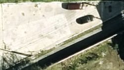
Non-Existent Buildings

$16.2M

Non-Existent Building Assessed Value (AV)

Overview

Parcel-Sense was developed to address a fundamental gap in mass appraisal: the inability to systematically verify the physical reality of improvements across an entire jurisdiction. Traditional workflows rely heavily on historical records, limited inspections, fragmented municipal data, and reactive corrections.

By leveraging parcel-level remote sensing and spatial analysis, Parcel Sense makes it possible to continuously validate assessment data against actual conditions on the ground at scale using the latest leaf-off aerial imagery.

Key Findings

The Cook County analysis revealed thousands of material discrepancies that would not be captured through standard processes. These findings were not isolated anomalies, but consistent patterns across the dataset.

Notably, over 1,600 properties were actively assessed as improved despite no existing structure, representing over $16 million in assessed value. In parallel, more than 6,000 garages were identified that were not recorded in parcel data.

Implications

These results highlight a structural limitation in current assessment systems: without scalable validation mechanisms, discrepancies accumulate over time. Parcel Sense provides a framework to proactively surface these issues, allowing jurisdictions to correct records, improve equity, and strengthen the integrity of the tax base.

Example Parcel Cases

Parcel 3008310022 2024 Building AV = $24,383.00
Improvement Probability ResNet = 0.00000017
Swin = 0.00000504
Wrecked in 2011
0 = Vacant, 1 = Improved
Parcel 1015323019 2024 Building AV = $28,424.00
Improvement Probability ResNet = 0.00000136
Swin = 0.000123835
Wrecked in 2010
0 = Vacant, 1 = Improved
Parcel 2918117024 2024 Building AV = $22,089.00
Improvement Probability ResNet = 0.00000015
Swin = 0.00000210
Wrecked in 2002
0 = Vacant, 1 = Improved
Parcel 1622216021 2024 Building AV = $20,519.00
Improvement Probability ResNet = 0.00000032
Swin = 0.00000189
Wrecked in 2018
0 = Vacant, 1 = Improved
Parcel 1615207040 2024 Building AV = $36,228.00
Improvement Probability ResNet = 0.00000027
Swin = 0.00000570
Wrecked in 2023
0 = Vacant, 1 = Improved
Parcel 3221202010 2024 Building AV = $4,456.00
Improvement Probability ResNet = 0.00003140
Swin = 0.00000167
Wrecked in 2007
0 = Vacant, 1 = Improved
Parcel 1623407008 2024 Building AV = $101,549.00
Improvement Probability ResNet = 0.000141269
Swin = 0.00001570
Wrecked in 2022
0 = Vacant, 1 = Improved
Parcel 1616110036 2024 Building AV = $16,445.00
Improvement Probability ResNet = 0.00001680
Swin = 0.00000713
Wrecked in 2015
0 = Vacant, 1 = Improved
Parcel 2436321027 2024 Building AV = $2,271.00
Improvement Probability ResNet = 0.00000760
Swin = 0.000319562
Last seen in historical aerials in 1988
0 = Vacant, 1 = Improved